


The data used for the storm footprints were generated by dynamically downscaling the ERA Interim re-analysis data set (Dee et al. 2011), from a horizontal resolution of ~0.7 degrees (spectral resolution T255 which is approximately 0.7 degrees, ~77km at the equator), to 0.22 degrees (~24km at the equator). The atmospheric model used to perform the downscaling was the Met Office Unified Model (MetUM; Davies et al., 2005). The downscaled domain covers western Europe and the eastern North Atlantic.
For this version of XWS, we have defined a storm footprint as the maximum 3-second gust at each grid point in the downscaled model domain over a 72 hour period. The 72 hour period is centred on the time which the tracking algorithm identified as having the maximum 925 hPa wind speed over land within a 3 degree radius of the track centre.
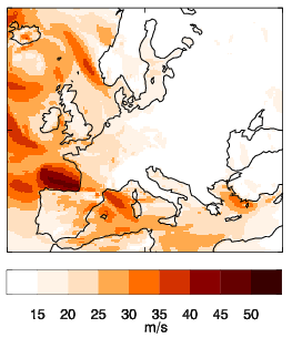
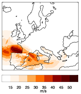
Because European storms often cluster in time (Mailier et al, 2006), it is likely that maximum gust footprints could include high gusts from two or more events. In order to minimise this footprint `contamination', instead of taking the maximum gust over the whole domain, at each 6 hour timestep all gusts outside a 1000km radius of the track position at that time are assumed not to be part of the event, and are set to `missing data' values. The footprint is then derived by taking the maximum of the remaining gusts.
The figures below show model maximum 3 second gust footprints for the storm Klaus (January 2009), where the left image is the raw data and the right image is the decontaminated data.
The format of the footprint data is described in the Data description page.
Licensing: The data provided on this site can be used for research and commercial purposes under the Creative Commons CC BY 4.0 International Licence: http://creativecommons.org/licenses/by/4.0/deed.en_GB. The following citation should be used for the XWS Datasets: (c) Copyright Met Office, University of Reading and University of Exeter. Licensed under Creative Commons CC BY 4.0 International Licence: http://creativecommons.org/licenses/by/4.0/deed.en_GB.
Disclaimer: The organisations involved give no warranty as to the quality or accuracy of the information on this website or its suitability for any use. Your use of information provided by this website is at your own risk.